A.1LogbookLogbuch
A.8
A.2Gebiete mit SauerstoffmangelAreas with low oxygen
A.3Was sind suboxische und anoxische Zonen?What are suboxic and anoxic zones?
A.4Wo der Ostsee "die Luft ausgeht"Where the Baltic "gasps for air"
A.5Was ist ein Salzwassereinbruch?What is a "Major Baltic Inflow"?
A.6Wie kommt das Salz in die Ostsee?How the salt gets into the Baltic
A.7Am Tropf der NordseeOn the drip of the North Sea
A.11Steckbrief der OstseeFact sheet of the Baltic Sea
A.12Lerne die Ostsee kennen!Get to know the Baltic Sea!
A.13Ostsee für EinsteigerBaltic Sea for Beginners
On a fixed route from the western to the central Baltic Sea, the IOW is monitoring a broad variety of environmental parameters several times per year. Auf einer Route von der westlichen bis in die zentrale Ostsee überwacht das IOW mehrmals jährlich eine Vielzahl von Umweltparametern.
More ...Mehr ...
The research vessel "Elisabeth Mann Borgese" is one of the most important tools for monitoring the environment of the Baltic Sea. Das Forschungsschiff "Elisabeth Mann Borgese" ist eines der wichtigsten Arbeitsmittel für die Umweltüberwachung in der Ostsee.
More ...Mehr ...
A simplified cross-section of the Baltic Sea along the IOW route specified for the HELCOM monitoring. Das Tiefenprofil der Ostsee entlang der IOW-Fahrtstrecke für die HELCOM-Umweltüberwachung.
More ...Mehr ...
I.1Legal noticeImpressum
x
I.2

Erstellt mit Mitteln der Forschungsstiftung Ostsee (Projekt-Nr. 17/2013)

Co-financed by funds the "Forschungsstiftung Ostsee" (Project # 17/2013)

Inhaltliche Gesamtkoordination: Leibniz-Institut für Ostseeforschung Warnemünde (IOW), Seestraße 15, 18119 Rostock, Ansprechpartner: Dr. Barbara Hentzsch, E-Mail: postmaster@io-warnemuende.de

Overall project coordination: Leibniz-Institute for Baltic Sea Research Warnemünde (IOW), Seestraße 15, 18119 Rostock, contact person: Dr. Barbara Hentzsch, E-Mail: postmaster@io-warnemuende.de

Technische Realisierung: Fraunhofer-Institut für Graphische Datenverarbeitung (IGD), Standort Rostock, Joachim-Jungius-Straße 11, 18059 Rostock, Ansprechpartner: Thomas Ruth, E-Mail: info@igd.fraunhofer.de

Technical realization: Fraunhofer-Institute for Computer Graphics Research (IGD), Joachim-Jungius-Straße 11, 18059 Rostock, contact person: Thomas Ruth, E-Mail: info@igd.fraunhofer.de

Wissenschaftliche Datengrundlage:

Background data:

Die hier dargestellten Animationen und Visualisierungen beruhen zum einen auf Messdaten, die das IOW und seine Vorgänger seit den 1970er Jahren in einem internationalen Messprogramm zur Überwachung des Zustandes der Ostsee erfasst haben, zum anderen auf Ergebnissen von Modellrechnungen der am IOW entwickelten Modellsysteme "ERGOM" und "GETM". Die Daten werden fortlaufend mit aktuellen Daten zu den Sauerstoffbedingungen im Tiefenwasser der Ostsee aktualisiert.

The animations and visualizations developed for this application are based on data collected by the IOW and its predecessors since the 1970s in the frame of international Baltic Sea monitoring programmes and by data derived from model simulations using the "ERGOM" and "GETM" models developed at IOW. In the future, data will be successively complemented with latest findings about oxygen conditions in the deep water of the Baltic Sea.

Für die Realisierung wurden genutzt:

Used for realisation:

  • jQuery JavaScript Library v2.1.1 (© 2005, 2014, jQuery Foundation, Inc. and other contributors)
  • D3 JavaScript Library v3.4.11 (© 2010-2014, Michael Bostock)
  • GSAP JavaScript Library 1.14.2 (© 2014, http://greensock.com/standard-license)
  • X3DOM JavaScript Library (© 2009-2015 Fraunhofer IGD, Darmstadt, Germany, http://www.x3dom.org)
  • Moment.js JavaScript Libary v2.9.0, http://momentjs.com
  • Underscore.js JavaScript Libary v1.7.0, http://underscorejs.org
  • Hammer.js JavaScript Libary v2.0.4, http://hammerjs.github.io
  • TopoJSON.js JavaScript Libary v1.6.19, https://github.com/mbostock/topojson
  • sockjs-client JavaScript Libary v1.0.0, http://sockjs.org
  • Stomp.js JavaScript Libary (© 2010-2013 Jeff Mesnil, http://jmesnil.net, © 2012 FuseSource, Inc., http://fusesource.com)
  • OceanView converter framework (© 2013-2015 Fraunhofer IGD, Rostock, Germany, http://igd-r.de/ocnvw)
  • Imagery © MapBox, Data from Natural Earth, public domain
  • Baltic Sea catchment area from HELCOM 2008, public domain

Version:

H.1HelpHilfe
H.2
Content
Inhalt
H.3
Function
Funktion
x
A.9

Das IOW und seine Vorgänger führen seit den 1970er Jahren ein Mess-programm zur Überwachung des ökologischen Zustandes der Ostsee durch.

The IOW and its predecessors are running a measuring programme for monitoring the ecological state of the Baltic Sea since the 1970ies.

Auf einer Strecke von der westlichen bis in die zentrale Ostsee werden fünf Mal im Jahr Umweltparameter gemessen, die für den Zustand charakteristisch sind. Zwei davon sind der Sauerstoff- und der Salzgehalt des Wassers.

On a fixed route from the Western to the Central Baltic Sea, characteristic environmental parameters for the ecological state are measured five times the year. Two of them are the oxygen content and the salinity of the water.

Why are we doing this?Warum machen wir das?

Die Ostsee ist nur durch sehr enge Wasserstraßen über die Nordsee mit dem Atlantik verbunden. Dadurch ist der Wasseraustausch sehr gering. Alles was in die Ostsee eingetragen wird, verbleibt hier relativ lange. Und es wird sehr viel eingetragen: aus einem Wassereinzugsgebiet, das viermal so groß ist wie die Ostsee selbst, gelangen Schad- und Nährstoffe hier her.

The Baltic Sea is connected to the Atlantic via the North Sea by very narrow water ways. This is the reason why the water exchange is so poor. Whatever enters the Baltic stays in there for a relatively long time. And there is a lot entering the Baltic: from a huge catchment area with four times the size of the Baltic Sea itself, pollutants and nutrients are carried in.

In den 1970er Jahren war der Zustand der Ostsee so besorgniserregend, dass alle Anrainerstaaten gemeinsam ein Monitoringprogramm beschlossen (das HELCOM-Monitoring), um die Entwicklung unter Kontrolle zu haben. Gleichzeitig fing man an, Verschmutzungsquellen zu beseitigen.

In the 1970ies, the state of the Baltic Sea was so alarming that all riparian states jointly agreed upon a monitoring programme – the so called HELCOM Monitoring – in order to control the development. Simultaneously, the remedy of pollution hot spots started.

Why are we measuring the oxygen content?Warum messen wir den Sauerstoff?

Für jegliches höheres Leben im Meer ist es wesentlich, dass das Meerwasser ausreichend mit gelöstem Sauerstoff versorgt ist. Am Boden der tiefen Ostseebecken ist er allerdings Mangelware. Hier sammelt sich sehr viel abgestorbenes organisches Material an. Bakterien zerlegen es in seine Grundbestandteile. Dabei verbrauchen sie Sauerstoff. Ist kein Sauerstoff mehr verfügbar, breitet sich giftiger Schwefelwasserstoff aus. Nur über den seitlichen Zustrom von Salzwasser aus der Nordsee kann Sauerstoff nachgeliefert werden.

For every higher marine life form it is essential to have the sea water supplied with sufficient dissolved oxygen. At the bottom of the deep Baltic Sea basins, however, oxygen is in short supply. It is here, that a lot of dead organic material is piled up and decomposed by bacteria into its basic elements. During this process, oxygen is consumed. When no more oxygen is available, toxic hydrogen sulphide is emerging. Only by a lateral inflow of saltwater from the North Sea, “fresh” oxygen can be supplied.

Why are we measuring the salinity?Warum messen wir den Salzgehalt?

Die Ostsee hängt "am Tropf" der Nordsee. Nur von dort kann Salz in die Ostsee gelangen. Diese Zufuhr ist allerdings sehr unregelmäßig. Unterbleibt sie über längere Zeiträume, so "süßt" die Ostsee aus. Für Meeresorganismen wird der Lebensraum dann ungemütlich. Süßwasserorganismen breiten sich aus.

It is a common saying that "the Baltic Sea is on the drip of the North Sea". It describes the fact that only from the North Sea, the Baltic Sea can receive its salt and oxygen. However, this supply comes on irregular terms, only. If it ceases for longer periods, the Baltic Sea´s water becomes "fresher" – which means less salty.
For marine organisms, the Baltic then becomes a very uncomfortable place. Freshwater organisms, on the other hand, welcome this development and extend their living space.
With the North Sea water, dissolved oxygen enters the Baltic, as well. As the salty North Sea water is denser and heavier than the Baltic Sea's brackish water, it is flowing along the bottom of the sea and thus can transport the oxygen even to the deep basins.

Einen Überblick über die wesentlichen Merkmale der Ostsee finden Sie im Steckbrief.

An overview of the main characteristics of the Baltic Sea can be found on the fact sheet.

A.10

Über die auf allen Seiten sichtbare Navigationsleiste können sie die Sprache wechseln, auf die Startseite zurückkehren und die Darstellung rotieren.

To change the language, to return to the start page, or to rotate the plot, please use the navigation menu available on every page.

Über interaktive Kacheln können verschiedene Themenbereiche geöffnet werden, z.B. "Gebiete mit Sauerstoffmangel".

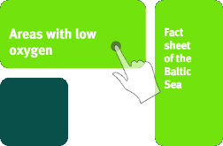
Different topics can be opened via interactive tiles, e.g. "areas with a low oxygen".

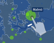
In der dargestellten Ostseekarte kann die Hauptroute der 4-5 mal jährlich stattfindenden Terminfahrten des IOW verfolgt werden. Wichtige Städte im Ostseeraum sind in der Karte eingezeichnet, durch Berühren der Punkte können die Städtenamen angezeigt werden.

In the displayed Baltic map the main route of the regular monitoring cruises, taking place 4-5 times the year, can be tracked. Important Baltic cities are marked and by touching the respective points, the city names can be displayed.